Lexicon
The following lexicon contains descriptions of the specific and techincal terms of photogrammetry.
If you are unfamiliar with the subject, then we would recommend you take a look at our brochure GET THE TOP VIEW: Wie ein Luftbild entsteht (only German version available).

A | B | C | D | E | F | G | H | I | J | K | L | M | N | O | P | Q | R | S | T | U | V | W | X | Y | Z
C
Camera systems
In the airplane supported photogrammetry digital and analogue camera systems are used. They have fixed focal lengths in common. A change of the image resolution can only be controlled by the altitude during operation. Furthermore these systems offer calibrated values for focal length, storage, picture format and pixel resolution. Additional devices record details like flight position and movement, which have to be considered as disturbances of the camera axis orthogenality during creation of the orthophoto.
Digital cameras are separated into surface based camera systems (DMC der Fa. INTERGRAPH, UltraCam der Fa. VEXCEL) and line measurement cameras (ADS40). The advantages of digital systems is their high radiometric resolution and precision, of the data capturing in separate colour channels, of the simultaneous capturing of RGB and NIR as well as the fast availability of the data in a digital process chain.
Analogue systems are film based cameras, e.g. the RMK TOP by Zeiss or the Leica RC 30. The image format is usually 23 x 23 cm on a roll of film that is scanned. During flight analogue cameras can produce either RGB colour or NIR. Should both image information be required, two separate flights have to be performed or two camera systems have to be aboard. The biggest disadvantage is that films take a long time to be developed and scanned.
Coordinate systems
Coordinate systems serve to define the location of a point on the earths surface. This coordinate represents the location in the respective coordinate system. Using geographic coordinates is common in daily application (e.g. Google Earth). For that the earth is divided evenly into 180 latitudinal and 360 longtitudinal degrees. Latitudinal coordinates are counted northward and southward from the equator. The longtitudinal coordinates start at the Grenwich meridian and are counted by eastern and western lengths.
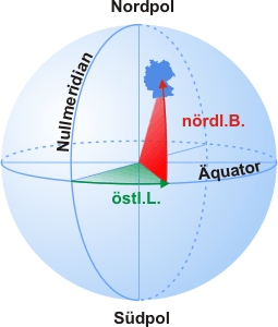
Geographic Coordinates
Since geodetic calculations on an ellipsoid are numerically inconvenient, a plane representation of the ellipsoid is commonly used. That way it is possible to get right angle coordinates (e.g. UTM). It is impossible to display the ellipsoid in the plane without distortion. To keep these distortions as small as possible, the displayed surface is divided into so called meridian lines. The following images give you an overview of the covered area.
Name | EPSG-Code | Ellipsoid | Mittelmeridian | Streifenbreite |
GKD¹ | --- | Bessel | 10,5° east. length | --- |
GK2 | 31466 | Bessel | 6° east. length | 3° |
GK3 | 31467 | Bessel | 9° east. length | 3° |
GK4 | 31468 | Bessel | 12° east. length | 3° |
GK5 | 31469 | Bessel | 15° east. length | 3° |
UTM32 | 31466 | WGS84 | 6° east. length | 6° |
UTM33 | 31466 | WGS84 | 12° east. length | 6° |
¹ ) GKD (GaußKrügerDeutschland) is a coordinate system, that covers the whole of Germany.
Gauß-Krüger Meridian lines:

UTM-Zones for Germany:

D
DLK Digital aerial image map
GeoContents core product is the aerial image mosaic of Germany based on our own flight photography. Its currently the only all inclusive and continually updated aerial image mosaic of its kind, which shows Germany in homogenous, colour orthophotos with a resolution from 10 to 50 centimeters.
In the process of restructuring the product classes in Summer 2007, the DLK became part of the TOPView.data brand, which also includes all other geospatial information, such as building coordinates and elevation models.
Digital building blocks / surface model
The digital building blocks provide details about the height of development and vegetation of a plot. It is generated based on stereoscopic aerial images, but also increasingly through laser and radar flight data. From this data 3D models of buildings with extensions are extrapolated to determine building height, plot dimensions and exposition.
Digital Terrain model
Unlike the surface model, the terrain model provides information about the elevation of an area on the surface. It serves as a basis for the generation of digital ortho images. The digital terrain model may take the form of a congruous raster or an incongruous triangular web, which also captures embankments and prominent landmarks.
G
GeoCoder
A GeoCoder is a software that finds the geographic coordinates to any given address. Through this process it is possible to localise an address. With this it is possible, for example, to visualise the address on the map, or to go to the appropriate section of the aerial image extract. Among others, we use our GeoCoder in our Webshop and to display aerial images or forcontract geocoding of any scale.
To find the appropriate coordinate, the system searches our database, which contains almost every address in Germany, including its respective coordinate. It is particularly important to us to also deliver good address results, if the data entry differs from the saved address. As a result you always get the addresses found by the system, including a percenage of similar results.
Geodata
... are digital information with a spatial aspect.
Georeferencing
... is the categorisation of geodata in to a reference coordinate system.
Georeferenced building addresses
are building databases that contain the exact geographic coordinate as well as the mailing address and official municipality and roadmap keys.
Ground resolution
The ground resolution in centimeters or meters signifies the length on the surface by a pixel in an orthophoto. This statement is often interpreted such that objects starting at this length become visible on the image (at a resolution of 50cm objects with a length of at least 50cm would be visible). Visibility depends on a number of factors however, for example the contrast of the object and its surroundings, which is why objects with a length smaller than the resolution are also often visible.
I
Infrared recordings (including NIR: near infrared)
Unlike RGB recordings, an infrared recording (Pseudo colour infrared) also includes reflections of the earths surface in the infrared spectral range. Especially the vegetation has a much higher reflection intensity in the spectral range, than is visible in the human range. Infrared recordings are used for analytical evaluations such as biotope type classification and vitality mapping.
Image tile
An orthophoto mosaic consists of individual orthophotos, that are joined together like a mosaic. To keep the amount of processed data as low as possible, such mosaics are often divided into image tiles (e.g. tiles of 1 km² each).
Image transformation
Image transformation is the geometric or radiometric transformation of an image (e.g. the transition between two coordinate systems).
Image editing
Image editing consists of a number of digital techniques to geometrically and/or radiometrically correct and improve raster data.
O
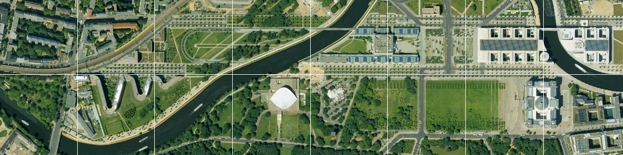
Orthophoto/orthoimage
An orthophoto is a realistic, distortion free and to-scale (photographic) representation of the earths surface. Orthogonal Orthogonal is Greek for right angle. In mathematics, orthogonality is the concept of the vertical and the right angle.
The term essentially describes that we look vertically on each point on the depicted surface.
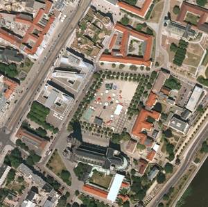
Orthophoto of the Magdeburg city centre (Dom and Hundertwasserhaus)
R
Radiometric attributes
... are determined through either the grey values or colour hue, brightness and saturation.
Raster and vector data
Raster data are made up of pixels. They are divided into columns and rows, usually square shaped and contain image information.
Vector data are digital data, presented in the form of dots, lines and shapes. They contain information about coordinates (length/height), spatial attributes and display definitions (colour, line thickness etc).
Recording method
Flying over an area in lines from east to west or north to south. The area is systematically and completely recorded with aerial photos. In the flight direction, 60% overlap is common of aerial images, while perpendicular to the flight direction, the overlap used is 30%.
T
Transformation
... is the changing of the shape or structure. The transformation takes place without loss of substance or content. In photogrammetry, transformation is the change of data into another format.
| AGB | Lizenzen | Impressum | Haftungsausschluss | Sitemap | Datenschutz |